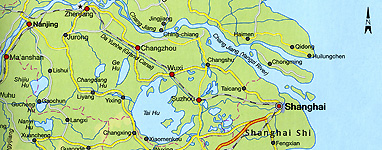
of the Yangzi River Delta

| Maps |
Please consult the links provided below for maps relevant to the sites, themes and topics relevant to the course. |
Lower Yangzi Delta (Jiangnan) |
Contemporary Jiangnan (English only): Insight Guide: China (Maspeth, NY: 1998), 251. (Note that this map, created for contemporary tourists, refers to the Jiangnan region simply as "Outside Shanghai") |
| Nanjing |
Google Maps default location |
Suzhou |
| Google Maps default location Suzhou in the Ming: Michael Marme, "Heaven on Earth: The Rise of Suzhou, 1127-1550," in Cities of Jiangnan in Late Imperial China (Albany: SUNY Press, 1993), 37. |
| Shanghai |
Google Maps default location |
Hangzhou |
| Goodle Maps default location Hangzhou, 1274: Arthur Wright, "The Cosmology of the Chinese City," in The City in Late Imperial China, ed. G. William Skinner (Stanford: Stanford University Press, 1977), 65. Hangzhou, Qing dynasty: Liping Wang, "Tourism and Spatial Change in Hangzhou, 1911-1927," in Remaking the Chinese City, ed. Joseph Esherick (Honolulu: University of Hawai'i Press, 2000), 109. NOTE: This map is reproduced from a traditional gazetteer, and is therefore oriented to the south. Hangzhou, 1920s: Wang, 114. NOTE: This map is oriented to the south for ease of comparison to the Qing dynasty map above. |
Shaoxing |
| Shaoxing, 1683: John R. Watt, "The Yamen and Urban Administration," in The City in Late Imperial China, ed. G. William Skinner (Stanford: Stanford University Press, 1977), 354. |
Beijing |
| Google Maps default location Beijing subway map: Wikipedia | |